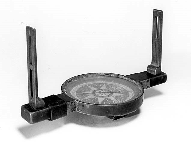
Compass surveying is a type of surveying.
It uses both angular and linear measurements to determine the position of an item.
Angle measurements are taken with a compass, whereas linear measurements are taken with a chain or tape.
In this article you’ll learn:
- Purpose of compass surveying.
- Types of compass surveying.
- Merits and Demerits of compass surveying.
- Lots more.
So, if you’re ready to go with compass surveying, this article is for you.
Let’s dive right in.
What is Compass Surveying?
The survey performed by a magnetic bearing compass device using the Travers method of measurement is known as a compass survey.
Compass surveying is not used in areas where iron cores, electric lines, and other structures attract magnetism due to their natural and electromagnetic properties.
Traversing is used in compass surveys.
A traverse is created by connecting the points of the plot with straight lines.

Purpose of Compass Surveying:
- If a vast area requires to be surveyed, such as the coastal areas or the river’s course line.
- Triangulation becomes impossible if the environment is densely packed with details and has several obstructions.
- If the surveyor is working on a large and detailed region, he or she may have a time limit.
Types of Compass Surveying:
1. Prismatic Compass:
It’s one of the most convenient and affordable magnetic compass options.
For measuring purposes, it can be carried in the hand or mounted on a tripod stand.
The line of sight is determined by the object vane and the eye vane.
A prismatic compass makes things simpler to conduct both sightings and readings at the same time. The graduation system in a prismatic compass.
The compass is initially held above the survey line’s starting station, and adjustments are made. After obtaining the magnetic meridian, the measurements are taken by seeing to the next station.
From the southern (0 degrees) to the western (90 degrees), northern (180 degrees), and eastern (200 degrees), the measurements rise clockwise (270 degrees).
The following are the most common prismatic compass surveying temporary adjustments:
- Centring.
- Levelling.
- Focusing on the Prism.
2. Surveyor Compass:
It comprises a magnetic needle enclosed in a circular brass container.
This needle swings around a 360-degree bass circle.
It is made up of two objectives that are used to measure the horizontal angle.
Along the north-south axis, this can be observed.
A surveyor’s compass is usually mounted on a tripod and levelled with a ball and socket mechanism.
The surveyor’s compass requires the same temporary adjustments as the prismatic compass.
Permanent adjustments for the surveyor compass surveying are occasionally required:
- Adjusting the Levels.
- needle adjustment.
- Sight vanes are adjusted.
- The Pivot is re-adjusted.
Difference between Prismatic Compass and Surveyor Compass:
| Prismatic Compass | Surveyor Compass |
| The magnetic needle and gradient are connected while the prism and box in the rotation. | The magnetic needle will be free when the dial is attached to the box. |
| Graduations are provided in clockwise 0-to-340-degrees. | The graduation is divided into 4 quarters, each quarter is marked with a 0- to 40-degree degree. |
| The reading is taken from the eyepiece of the prism at the south end of the compass. | The reading can be taken directly by dial where the north end of the needle. |
| The initial reading starts from the south of the instrument. | The initial reading begins at the north end of the instrument. |
| East and west positions are stable. | The position of East and West are changed. |
| No tripod is required; the survey can be done by a hand-held device. | The tripod must hold the instrument. |
| We can get a full circle bearing. | We can only get a reduced bearing. |
Advantages of Compass Surveying:
- They are lightweight and portable.
- When it comes to maintaining it on a station, they have fewer alternatives.
- A single survey line’s direction inaccuracy has no bearing on subsequent survey lines.
- It can be used to retrace earlier surveys.
Also, read: Chain Surveying
Disadvantages of Compass Surveying:
- It is less exact than other modern surveying technologies.
- It is easily subjected to different errors such as magnetic meridian errors, local attraction errors, and so on.
- Errors are also caused by poor sighting of the range rods and improper levelling.
Also, read: Total Station
Application of Compass Surveying:
- A magnetic compass can be used to determine the magnetic bearings of a line.
- The whole bearing system (WBS) and quadrantal bearing system (QBS) are the two methods for measuring bearings (QBS).
- The compass survey used for measurement determines this completely.
- The magnetic meridian at the observation location is established when a small strip of steel or iron is polarised and hanging at its centre, allowing it to freely fluctuate along the vertical axis.
Also, read: Plane Table Surveying
Conclusion:
As a result, using a compass and a tape traverse, stations were established and information about the area was obtained & map was constructed.

Related Posts
Rock Quality Designation(RQD): Building Strong Foundations
Spread Footing
Masonry Cement
Plain Cement Concrete
Concrete Efflorescence
Concrete Pile
Stepped Footing
Fineness Modulus of Coarse Aggregates
Difference between Condo and Apartment