
Levelling is used to determine the height of the given points above or below the datum line or to set the required height above or below the datum line in the given points.
It evolves measurements in vertical scales.
Levelling is defined to check or measure the height of specified points in relation to a datum.
In this article you’ll learn:
- Introduction of levelling.
- Types of levelling.
- Merits and Demerits of levelling.
- Lots more.
So, if you’re ready to go with levelling, this article is for you.
Let’s dive right in.
Introduction to Levelling:
Before starting construction of highways, dams or any other construction, the most important part of the survey is levelling.
It is a type of survey that involves measuring the height of a point in relation to a datum level above or below the ground surface.
It’s commonly used in mapping to determine geodetic height as well as in construction to determine height differences.
The term levelling is used to determine the elevations of locations or variations in altitude.
Basic Terms Used in Levelling:
A level surface:
It is referring to any surface that is parallel to the earth’s mean spheroid and a level line is a line drawn on a level surface.
A horizontal surface:
At a point refers to any surface that is tangential to a level surface at a given location. The horizontal line parallels the plumb line.
Vertical surface:
The line connecting the earth’s tip and center. The azimuth and elevation lines are perpendicular to each other.
Datum or surface refers to the point or surface from which the levels of other points or planes are determined.
Mean sea level (MSL):
Mean Sea level is the average height of the water throughout all phases of the wave (MSL). Any given location is determined on an average over a period of 19 years.
The mean sea level used in India is Karachi (Pakistan). It is used as data in all major surveys.
The reduced level: is the height at which the various points on the datum surface are measured.
Benchmark:
A benchmark is a relatively fixed point of reference, the height of which is known in terms of assumed information. There are four different types of benchmarks.
Types of Levels:
Dumpy Level: Most often used in construction.
The telescope is permanently linked to a bubble, and the equipment is adjustable using a screwed ball joint as well as foot screw that is changed in one direction initially, then at 900.
Y Level: The Y level is also known as the wye level. It has a Y-shaped structure that holds the telescope in place and a vertical spindle that aids in rotation. These binoculars can be used to perform rapid adjustment tests in a short period of time.
Cooke’s Reversible level: It is a hybrid of the y-level and the dumpy level. Since the right and left bubbles of the telescope are being read, it reduces collimation errors.
Tilting Level: A spherical bubble and a primary bubble attached to the telescope are included in this type of level as a first approximation.
For every observation, the primary bubble is observed via the eyepiece, and the binoculars are tilted by a tiny adjustment to brought the two ends of the bubble close.
Auto Level: It has a compensator which is made up of three prisms arranged in a triangle. The telescopic lens is linked to the two outer sections.
The micro-wiring suspends the central prism which response to gravity. A round bubble is used to simulate the levelling of the instrument.
The compensatory approach differs from the level of the telescope.
Cushing’s Level: The eyepiece of this telescope and the end of the object are interchangeable or reversible, however, they are not removable or rotatable in its longitudinal axis.
Types of Levelling:
Simple Levelling:
It is the difference in levels between two points that are close together.
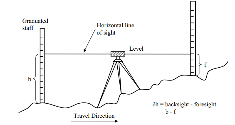
Differential Levelling:
When the distance between two places is very large, readings from a single set of instruments may not be possible. Taking change point (CP) made each shift go more easily.
Fly Levelling:
Involves levelling with respect to a temporary benchmark in a convenient direction while keeping count of the number of change points (CP).
Cross-sectioning:
In many engineering projects, not only levelling staff (LS) but also CS of the ground is obtained at regular intervals to calculate earthwork.
Reciprocal Levelling:
Is employed when it is impossible to balance foresight (FS) and back sight (BS) due to the non-parallelism of the calibration line and the axis of the bubble tube, as well as curvature and refraction.
Profile Levelling:
Is also known as longitudinal section levelling. In lines or sets of lines reduced levels of different points are found at regular intervals.
Engineers then create profiles from the sectional view line of the land. This method of levelling is frequently used to fix railways, roads, canals and sewers.
Errors in Levelling:
The errors in Levelling are classified as follows:
1. Instrumental error and Correction:
Collimation error Correction: Inspect and adjust sights before being used.
Within a delicate bubble.
Staff graduation mistakes Check the spelling.
Remove the tripod head.
The telescope is not parallel to the bubble pipe Correction: A permanent change.
The telescope is not perpendicular to the vertical axis. Correction: A permanent change.
2. The error of Collimation:
When the equipment is level, collimation error arises when the collimation axis isn’t really truly horizontal.
3. Curvature & Refraction:
Because the earth is curved, the level surface via the telescope will deviate from the horizontal plane as line-of-sight progresses to the horizon.
4. Other sources of errors in levelling:
The instrument was incorrectly set up.
When switching level stations, employees must leave their positions.
The staff is not oriented vertically.
Parallax occurs when an equipment is struck or moved throughout a backsight-foresight measurement.
A tripod or rod rests during measurements, for example- off-centre bubble Levelling is a method of calculating the height of items on the ground’s area.
Advantages of Levelling:
- Levelling is a technique of determining the height of objects on the surface of the ground.
- It is used in constructing the road’s centre line.
- The data obtained during the levelling process helps in understanding the topography of the soil.
- Levelling is extremely useful when it comes to developing structures.
Disadvantages of Levelling:
- The levelling process takes a long time.
- Too expensive.
- The levelling process requires skilled and qualified experts.
- Plotting strata on a map or sheet takes time and need numerous computations.
Application of Levelling:
- Design of highways, roads, canals, sewers, water supply systems, etc., with grade lines that best confirm the current topography:
- Laying of the construction project as per planned height.
- to find the number of earthworks and other components.
- Checking the drainage characteristics of the area etc.
Also read: Contour Interval | Plinth Level & Sill Level | Theodolite Surveying | Compass Surveying
Conclusion:
Levelling has importance in fieldwork including it helps surveyors or cartographers to make a contour map of land and sea surfaces.
This establishes benchmarks and aids in the development of transportation routes such as roads and railroads.
It also assists builders in laying a level ground on which to create a level building.
Assists pipe transport designers in ensuring adequate terrain slopes for a smoother flow of liquid in transit time.
Related Posts
Rock Quality Designation(RQD): Building Strong Foundations
Spread Footing
Masonry Cement
Plain Cement Concrete
Concrete Efflorescence
Concrete Pile
Stepped Footing
Fineness Modulus of Coarse Aggregates
Difference between Condo and Apartment