
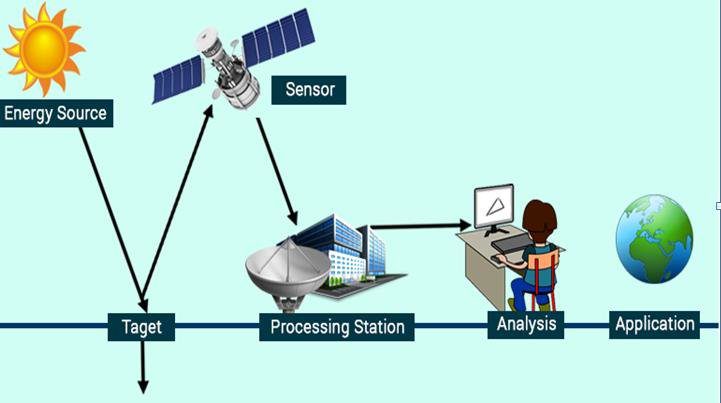
Remote sensing is a technique of detecting and monitoring the physical features of a location.
It is used to measure the scattered and transmitted radiation from a distance.
In this article you’ll learn:
- What is Remote Sensing?
- Types of Remote Sensing.
- Merits and Demerits of Remote Sensing.
- Lots more.
So, if you’re ready to go with it, this article is for you.
Let’s dive right in.
Introduction to Remote Sensing:
In the early 1960s, the terminology “remote sensing” was introduced.
This basically requires an object surface, a recording device, and information-carrying energy waves.
It was later defined as the whole procedure used to obtain and measure information about some characteristic of objects.
Using a recording device (sensor) that is not in direct contact with the objects and phenomena under investigation.
Types of Remote Sensing:
Active Remote Sensing:
This sensing involves the propagation of a coherent EM wave at a target, which can be an astronomical object or a position on the ground.
The time it takes for the sent EM wave to return to the receiver.
the phase information of the received EM wave is two additional features that the active system does not normally evaluate.
In some situations, both active and passive are active in polarization, but radar receives extra information from the Doppler shift.
Passive Remote Sensing:
The optical regime depends upon two sources of radiation for passive sensing.
The radiation is recorded by a remote sensing system emitted by the sun in the visible to wavelength infrared region.
A proportion of the radiation received by a sensor was reflected at the earth’s surface, whereas the remaining is scattered by the atmosphere and never reached the earth.
Thermal radiation is produced directly by materials on the earth in the thermal infrared, and as it propagates above, it merges with self-emitted infrared light in the atmosphere.
The essential models for the optical region, from visible to thermal infrared, are stated in this section.
Advantages of Remote Sensing:
- It allows for massive coverage, providing for regional surveys on a number of topics and the detection of relatively big features.
- When collecting data on dynamic subjects like water, agricultural areas allows for periodic coverage.
- It can capture data at a variety of scales and resolutions.
- A single remote sensing image can be examined and interpreted for usage in a variety of applications and objectives. The quantity of data that may be extracted from a single remotely sensed image is virtually limitless.
- Remotely sensed data is easily processed and analyzed on a computer, and the information can be used for a variety of reasons.
Disadvantages of Remote Sensing:
- When measuring or evaluating smaller areas, sensing is a costly way of analysis.
- It necessitates specialized expertise in order to determine the images. Using sensing technology is more expensive in the long term because users of the device require additional training.
- If you need to evaluate multiple elements of photographic qualities, it’s expensive to examine repeated images.
- Devices used may be out of range at times leading to uncalibrated data.
Applications of Remote Sensing:
Land Use Mapping:
Remote sensing data can be used to obtain the most up-to-date land-use patterns for large areas at any given time, as well as to record changes over time.
It can be used to upgrade road maps, check asphalt conditions, and define wetland areas.
Regional planners and administrators use this data to develop policies for the region’s overall development.
It is widely employed for weather forecasting. It’s also used to inform users of approaching cyclones.
Weather Forecasting:
Remote sensing is widely employed for weather forecasting.
It’s also used to inform users of approaching cyclones.
Environmental Study:
It can be used to analyse deforestation, land degradation, air pollution, degradation, eutrophication of huge bodies of water, and leakages from oil tankers.
Study of Natural hazards:
Earthquakes, volcanoes, landslides, floods, and ice melting in polar regions can all be researched.
It may often be used to detect the occurrence of natural calamities.
Resource exploration:
The sensing data is important for automatically updating geological maps, generating physiographic and tectonic maps quickly, locating mineral quarrying sites, and locating fossil fuel resources.
Related Articles: Theodolite Surveying | Reconnaissance Survey | Compass Surveying
Conclusion:
Although remote sensing techniques have generally been considered as a means of acquiring data to be interpreted by the user, they are increasingly being used in scientific and applied research for other purposes.
The sensing data on natural and anthropogenic variables like vegetation cover, land use, topography, and hydrography are used as input to a variety of simulation models, including hydrological, atmospheric, ecological, and economic models.
Researchers merge classified pictures of land use and land cover with demographic and socioeconomic information to generate models that help them better understand processes like deforestation and land-use conversion.
Related Posts
Rock Quality Designation(RQD): Building Strong Foundations
Spread Footing
Masonry Cement
Plain Cement Concrete
Concrete Efflorescence
Concrete Pile
Stepped Footing
Fineness Modulus of Coarse Aggregates
Difference between Condo and Apartment