
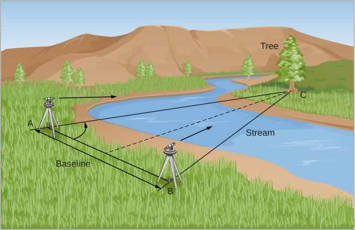
Triangulation is a surveying technique in which the angles consisting of three survey control points in a triangle are measured.
The other measurements in the triangle are calculated using trigonometry and only one side’s measured value.
In this article you’ll learn:
- Introduction to triangulation surveying.
- Types of triangulation surveying.
- Merits and Demerits of triangulation surveying.
- Lots more.
So, if you’re ready to go with triangulation surveying, this article is for you.
Let’s dive right in.
Introduction to Triangulation Surveying:
The method of measuring the angle of a chain of triangles produced by stations marked on the earth’s surface is known as triangulation.
If all 3 angles and the measure of one side of a triangle are known, the length of the other sides of the triangles can be computed by triangulation surveying.
Similarly, the rest vertices of a triangle can be determined using simple trigonometry given the coordinates of any vertex and azimuth are specified.
Types of Triangulation Surveying:
The precision with which a triangulation line’s length and azimuth are determined via triangulation.
The precision of triangulation systems is determined by the scope and purpose of the survey.
Primary Triangulation Surveying (first-order):
First-order triangulation is used to compute the earth’s topography or to offer the most precise control points toward which secondary triangulation can be correlated.
The following are the basic triangulation’s main requirements:
- Approximate time to close a triangle: less than a second.
- Triangle closure time limit: no more than 3 seconds.
- Baseline dimensions: 5–10 kilometres.
- Triangle side lengths range from 30 to 150 kilometres.
- Actual base inaccuracy: 1 per 300,000.
- Probability of base inaccuracy: 1 in 1,000,000.
- The vast difference between the two sectional measurements: 10 mm kilometres.
- Probability of mistake or calculated distance: 1 per 60,000 to 250,000.
- Probable astronomical azimuth inaccuracy: 0.5 secs.
Secondary Triangulation Surveying (second-order):
A number of points that are defined within the primary triangulation framework make up the secondary triangulation.
The stations are spaced closely enough apart that the resulting triangles are smaller than the initial triangulation.
The instruments and methods used aren’t as developed as they could be. A group of points that are defined within the primary triangulation framework make up the secondary triangulation.
The following are the main requirements for secondary triangulation:
- Average time to close a triangle: 3 seconds
- 8 seconds is the maximum time for a triangle to be closed.
- As a beginning point, aim for 1.5 to 5 kilometres.
- Triangle sides range from 8 to 65 kilometres long.
- 1 in 150,000 chances of a base mistake
- The probability of a base mistake is 1 in 500,000.
- The variation in measurements between the two sections is as follows: 20-millimetre km
- 1 per 20,000 to 1 per 50,000 chances of inaccuracy or estimated distance.
- Calculated astronomic azimuth inaccuracy: 2.0 sec.
Tertiary Triangulation Surveying (third-order):
Third-order triangulation, which comprises various points produced inside the structure of secondary triangulation is the basic control for extensive technical as well as other surveys.
The following are the main requirements for tertiary triangulation:
- The average triangle closing criteria are 6 seconds.
- Triangle closure time limit: 12 seconds.
- Baseline dimensions: 0.5 to 3 km.
- Triangle side lengths range from 1.5 to 10 kilometres.
- Actual base inaccuracy: 1 in 75,0000.
- Probable base inaccuracy: 1 in 250,000.
- The difference in sectional measurements: 25 mm kilometres.
- Chance of inaccuracy or calculated length: 1 per 5,000 to 1 per 20,000
- Calculated astronomic azimuth inaccuracy: 5 seconds.
Advantages of Triangulation Surveying:
- For longer distances, triangulation offers precise measurements.
- It is both inexpensive and simple to apply.
- Triangulation observations do not require the use of specialized techniques or infrastructure.
- When measuring longer distances, triangulation makes the work easier.
Disadvantages of Triangulation Surveying:
- It involves more points to consider a measurement, triangulation is difficult to apply for many small surfaces or regions.
- To deal with triangulation, you’ll need specific knowledge and experience.
- Before making reliable measurements, triangulation needs substantial surveying skills.
- Involves additional time and effort to collect measurements from various sites.
Application of Triangulation Surveying:
- Providing precisely positioned control points during large-area plane and geodesy surveys.
- Aerial surveying requires the establishment of precisely situated control points.
- The precise location of engineering projects such as long tunnel centre lines, terminal points, chambers, and long-span bridge centre lines and abutments.
Related Articles: Compass Surveying | Theodolite Surveying | Plane Table Surveying
Conclusion:
As a result, a fourth-order triangulation station was constructed, which can be employed for mapmaking applications such as cadastral mapping and topographical mapping.
Triangulation surveying is also suitable for a variety of engineering jobs.
Related Posts
Refresh Your Office: Simple Ideas to Boost Productivity and Motivation in Your Workplace:
Understanding the Nuances of Office Chair Vs Ergonomic Chair to Select Better!
Rock Quality Designation(RQD): Building Strong Foundations
Spread Footing
Masonry Cement
Plain Cement Concrete
Concrete Efflorescence
Concrete Pile
Stepped Footing